UTTARAKHAND: GLACIER LAKE OUTBURST
WHY IN NEWS?
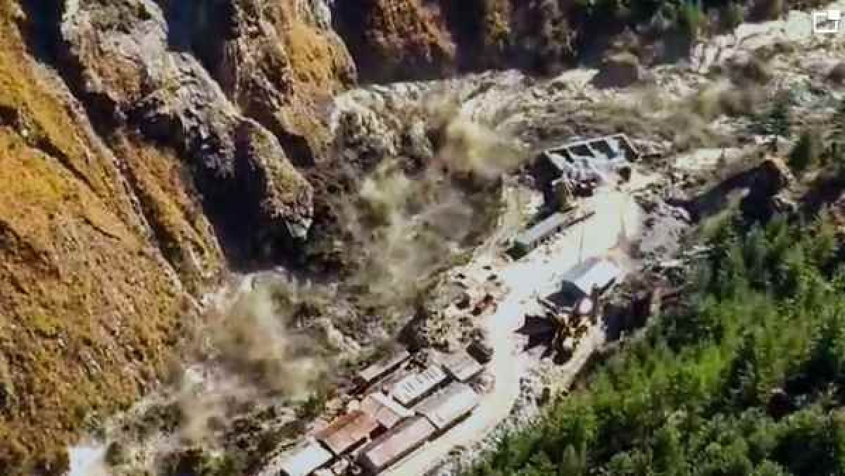
- Recently, aglacial break in the Tapovan-Reni area of Chamoli District of Uttarakhand led to massive Flash Flood in Dhauli Ganga and Alaknanda Rivers, damaging houses and the nearby Rishiganga power project. In June 2013, flash floods in Uttarakhand wiped out settlements and took lives.
KEY POINTS
- CAUSE OF FLASH FLOOD – It occurred in river Rishi Ganga due to the falling of a portion of Nanda Devi glacier in the river which exponentially increased the volume of water.
- Rishiganga meets Dhauli Ganga near Raini. So Dhauli Ganga also got flooded.
- Major Power Projects Affected:
- Rishi Ganga Power Project – It is a privately owned 130MW project.
- Tapovan Vishnugad Hydropower Project on the Dhauliganga – It was a 520 MW run-of-river hydroelectric projectbeing constructed on Dhauliganga River.
- Severalother projects on the Alaknanda and Bhagirathi river basins in northwestern Uttarakhand have also been impacted by the flood.
FLASH FLOODS
ABOUT:
- These are sudden surges in water levels generally during or following an intense spell of rain.
- These are highly localised events of short duration with a very high peak and usually have less than six hours between the occurrence of the rainfall and peak flood.
- The flood situation worsens in the presence of choked drainage lines or encroachments obstructing the natural flow of water.
CAUSES
- It may be caused by heavy rain associated with a severe thunderstorm, hurricane, tropical storm, or meltwater from ice or snow flowing over ice sheets or snowfields.
- Flash Floods can also occur due to Dam or Levee Breaks, and/or Mudslides (Debris Flow).
- In areas on or near volcanoes, flash floods have also occurred after eruptions, when glaciers have been melted by the intense heat.
- The intensity of the rainfall, the location and distribution of the rainfall, the land use and topography, vegetation types and growth/density, soil type, and soil water- content all determine just how quickly the Flash Flooding may occur, and influence where it may occur.
What makes the geography of Uttarakhand so fragile and vulnerable to such incidents?
- This is a natural event that occurred in the high Himalayan ranges. They happen every now and then.
- Except this one is closer to a populated area. Secondly, we would have never heard of it, if it had not led to a disaster. There is a natural event and that is okay. But disasters happen when we do something stupid.
- In 2013, after the Kedarnath tragedy, the committee that was heading put out a report which clearly said that projects should not be built in these valleys.
- They are called paraglacial zones – glaciers in the geological pass have receded from this area leaving behind a lot of debris, boulders, rocks, etc.
- And when there is heavy rainfall or snowfall, and there is melting of water, snow and ice – the combination of the three is deadly – then it is able to gather a lot of the solids lying in the path and move them downstream.
- We had described the process of how destruction takes place and we had clearly said not to build them. This valley had six projects planned. To ignore this warning is foolhardy.
Increasing frailty in the face of environmental shocks:
- The Centre and the Uttarakhand government cannot ignore the larger context of the State’s increasing frailty in the face of environmental shocks.
- Once the crucible of environmentalism, epitomised by Sunderlal Bahuguna, Gaura Devi and the Chipko movement, the State’s deep gorges and canyons have attracted many hydroelectric projects and dams, with little concern for earthquake risk.
- Red flags have been raised repeatedly, particularly after the moderate quake in 1991 in the region where the Tehri dam was built and the 2013 floods that devastated Kedarnath, pointing to the threat from seismicity, dam-induced micro-seismicity, landslides and floods from a variety of causes, including unstable glacial lakes and climate change.
- India is heavily invested in dam development and growth of hydropower, largely in the Himalayan region specially to cut carbon emissions.
- By one estimate, if the national plan to construct dams in 28 river valleys in the hills is realised in a few decades, the Indian Himalayas will have one dam for every 32 km, among the world’s highest densities.
- Yet, as researchers say, this may be a miscalculation for reasons, including potential earthquake impacts, monsoonal aberrations that could repeat a Kedarnath-like flood, severe biodiversity loss and, importantly, extreme danger to communities downstream.
GLACIERS
- Glaciers are a bulk of ice moving under its weight. It forms in areas where the amassing of snow goes beyond its ablation over many years.
- They are generally seen in the snow-fields.
- This largest freshwater basin covers around 10% of the land surface of the Earth.
- According to the topography and the location of the glacier, it can be categorized as Mountain Glacier (Alpine Glaciers) or Continental Glacier (Ice Sheets).
- The Continental Glacier moves outward in all directions whereas the Mountain Glacier moves from a higher to a lower altitude.
Glaciers and Floods:
- Glacial Lakes:
- Retreating glaciers, like several in the Himalayas, usually result in the formation of lakes at their tips, called proglacial lakes,often bound only by sediments and boulders.
- Flood:
- If theboundaries of these lakes are breached, it can lead to large amounts of water rushing down to nearby streams and rivers, gathering momentum on the way by picking up sediments, rocks and other material, and resulting in flooding downstream.
Impact of Climate Change:
- Climate change has driven erratic weather patterns like increased snowfall and rainfall, warmer winters has led to the melting of a lot of snow.
- According to the latest assessment reports of the UN Intergovernmental Panel on Climate Change, glacier retreat and permafrost thaw are projected to decrease the stability of mountain slopes and increase the number and area of glacier lakes.
DHAULIGANGA
- ORIGIN – It originates from Vasudhara Tal, perhaps the largest glacial lake in Uttarakhand.
- ABOUT:
- Dhauliganga is one of the important tributaries of Alaknanda,the other being the Nandakini, Pindar, Mandakini and Bhagirathi.
- Dhauliganga is joined by the Rishiganga river at Raini.
- It merges with the Alaknanda at Vishnuprayag.
- There it loses its identity and the Alaknanda flows southwest through Chamoli, Maithana, Nandaprayag, Karnaprayaguntil it meets the Mandakini river, coming from the north at Rudraprayag.
- After subsuming Mandakini, the Alaknanda carries on past Srinagar, before joining the Ganga at Devprayag.
-
- Alaknanda then disappears and the mighty Ganga carries on its journey, first flowing south then west through important pilgrimage centres such as Rishikesh and finally descending into the Indo-Gangetic plains at Haridwar.
NANDA DEVI NATIONAL PARK
- Location – It is situated around the peak of Nanda Devi (7816 m) in the state of Uttarakhand in northern India.
- About – The park encompasses the Nanda Devi Sanctuary, a glacial basinsurrounded by a ring of peaks, and drained by the Rishi Ganga through the Rishi Ganga Gorge.
- Established – The Park was established as Sanjay Gandhi National Park by Notification in 1982 but was later renamed Nanda Devi National Park.
- It was inscribed a World Heritage Siteby the United Nations Educational, Scientific and Cultural Organization (UNESCO) in 1988.
- Flora – Some 312 floral species that include 17 rare species have been found here. Fir, birch, rhododendron, and juniper are the main flora.