AUSTRALIA DECLARES ‘LA NINA WEATHER EVENT BEGINS’
- Weather bureau of Australia declared on November 23, 2021 that; a La Nina weather phenomenon had developed in Pacific Ocean for the second consecutive year.
Highlights
- Development of this phenomenon will bring above average rainfall across central, north and east Australia.
- This event could boost wheat yields in Australia.
- In September 2021, India had increased its wheat forecast for this season by 17 per cent to near record levels because of favourable weather.
- This year, climatic models suggest, La Nina pattern will be short-lived, and will be effective until late southern hemisphere summer or early autumn 2022.
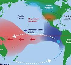
What is La Nina?
- La Nina is an oceanic and atmospheric phenomenon, which is a colder counterpart of El Nino.
- It is a part of broader El Nino–Southern Oscillation (ENSO) climate pattern. Name of La Nina originates from Spanish for ‘the girl’.
- Phenomenon of La Nina is usually associated with more tropical cyclones, greater rainfall, and cooler than average temperatures in equatorial Pacific Ocean. The events typically last about a year.
What happens during La Nina?
- During La Nina period, sea surface temperature across eastern equatorial part of central Pacific Ocean becomes lower than normal by 3–5 °C.
Impact of La Nina
- La Nina has an extensive effect on weather worldwide, especially in North America.
- It also impacts the Atlantic and Pacific hurricane seasons, in which number of tropical cyclones increases in Atlantic basin because of low wind shear and warmer sea surface temperatures.
- It also reduces tropical cyclogenesis in Pacific Ocean.